Cameroon Map Guide: Regions, Borders, Cities & Travel Orientation
A Cameroon map is more than a simple drawing of borders and lines. For anyone planning to visit, invest, or relocate, the map is a vital survival tool. It explains why a 200km journey might take six hours, why you need a sweater in one town and a fan in another, and how the "Africa in Miniature" nickname is physically etched into the landscape.
This guide provides a practical breakdown of the Cameroon map so that the geography becomes a usable asset for your daily life and travel planning.
 Map of Cameroon showing all 10 regions and major cities for easy travel orientation.
Where is Cameroon Located?
Looking at a global Cameroon map, you will find the country situated in the "armpit" of Africa. It sits at the junction of West and Central Africa, bordering the Bight of Biafra (part of the Atlantic Ocean).
This specific location is geographically significant for several reasons:
- The Coastline: Our access to the Atlantic influences the humidity of our major economic hubs.
- The Bridge: Being the "hinge" between two sub-regions makes Cameroon a strategic trade and transport corridor.
- The Diversity: Its vertical stretch from the coast to the Lake Chad basin is why the Cameroon map transitions from tropical rainforests to semi-arid sahel.
Cameroon's Neighbours
Cameroon has six neighbouring countries. These countries are Nigeria, Central African Republic, Congo, Gabon and Equatorial Guine
- South west of Cameroon is the Gulf of Guinea.
- Northwest of Cameroon is Nigeria.
- East of Cameroon is Central African Republic
- North of Cameroon is Chad and
- South of Cameroon are Congo Brazzaville, Gabon and Equatorial Guinea.
Navigating Cameroon’s Borders
A practical Cameroon map highlights our neighbors: Nigeria to the west; Chad to the northeast; the Central African Republic to the east; and Equatorial Guinea, Gabon, and the Republic of the Congo to the south.
Understanding these borders is essential for:
- Regional Travel: Planning cross-border road trips or flights.
- Trade Routes: Recognizing why certain northern cities are hubs for Chadian trade.
- Cultural Overlap: Realizing how traditions often flow across these political lines.
Understanding Map Zones and Regions
While the official Cameroon map is divided into ten administrative regions, travelers and residents benefit more from thinking in geographical "zones."
1. The Coastal Zone
Dominated by the Littoral and South regions, this area is characterized by heavy rainfall and high humidity.
- Key City: Douala – The nation’s port-based economic engine.
- Vibe: Bustling, tropical, and fast-paced.
2. The Central Zone
The heart of the country, featuring plateaus and rolling hills.
- Key City: Yaounde – The political and administrative capital.
- Vibe: Cooler than the coast, organized, and hilly.
3. The Western Highlands
This is the "Green Zone" of the Cameroon map. It includes the West and North West regions.
- Key Cities: Bafoussam and Bamenda.
- Vibe: High elevations, strong agricultural roots, and brisk, refreshing air.
4. The Mountain Zone
Mainly concentrated around the Fako division.
- Key Landmark: Mount Cameroon.
- Key City: Buea.
- Vibe: Rapid weather shifts and an outdoor enthusiast's paradise.
 Lush greenery of the Western Highlands of Cameroon
My Personal Experience: 30 Years Exploring the Map
Over three decades of living in and moving across Cameroon, I have learned that the Cameroon map is a living entity. I have traversed the dusty roads of the North, where the horizon seems infinite, and navigated the winding, mist-covered hairpins of the "Cliff of Santchou" in the West.
I remember my first move from the humid coastal heat of Douala to the chilly heights of the North West. I hadn't studied the map’s elevation markers properly and arrived with only light tropical clothing—a mistake I never made again! Exploring this map taught me that Cameroonians are as diverse as their geography. Whether I was sharing a meal in a small village near the CAR border or navigating the administrative corridors of Yaoundé, the map was my constant companion in understanding the "why" behind the local lifestyle.
Why Distance Does Not Equal Time
The biggest mistake people make when looking at a Cameroon map is using a standard "kilometers to hours" calculation. Geography dictates travel speed here.
- Terrain: Crossing mountain ranges or dense forest zones slows movement.
- Road Conditions: Map lines don't always reflect current road quality.
- Congestion: Urban sprawl around Douala and Yaoundé can turn a 20km trip into a 2-hour ordeal.
Always plan conservatively. If the map says 300km, allow for a full day of travel to stay safe and stress-free. For more on movement, see our Cities & Regions Guide.
How the Map Explains the Weather
The Cameroon map is a "Weather Predictor."
- Coastal towns (like those found in our (Cameroon Beaches Guide) will always be humid.
- The Highlands will always require a jacket for the evenings.
- The Far North will experience the most intense dry seasons.
For a deeper dive into these patterns, consult the Cameroon Weather and Climate Guide.
Final Perspective on the Cameroon Map
Using a Cameroon map correctly allows you to answer the "Big Four" questions:
- Which region am I visiting/relocating to?
- What climate should I pack for?
- How close am I to a major healthcare or commercial hub?
- How will the terrain affect my daily movement?
Geography is the foundation of the Cameroonian experience. By mastering the map, you master the country.
External Reference:
For official geographical data and administrative boundaries, you can consult the National Institute of Statistics - Cameroon.
Share This Page
Join the Journey - Stay Updated
Stay Updated
Get insights on:
Cameroon Travel Guide and more
Recent Articles
-
Cameroon Newsletter: Real Insights, Travel, Living & Opportunities
May 16, 26 04:43 AM
 Join this Cameroon newsletter for practical insights on travel, living, safety, diaspora realities, and opportunities in Cameroon.
 -
Cameroon in Transition: Mourning, Power Shifts, and an Energy Revolution Shake the Nation
May 11, 26 04:05 AM
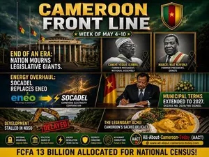 Yaoundé | May 10, 2026 — Cameroon has just emerged from one of the most dramatic and emotionally charged weeks in recent memory. Between May 4 and May
 -
Doing Business in Cameroon Explained
May 03, 26 11:42 AM
 A practical guide to doing business in Cameroon explained, including small businesses, informal economy realities, risks, bureaucracy, and survival strategies.